As part of the ongoing Black Sea Maritime Archaeology Project (MAP) the University of Southampton’s Centre of Maritime Archaeology, in partnership with the Centre for Underwater Archaeology in Sozopol, carried out underwater excavations at the multi-period site of Ropotamo by the Bulgarian Black Sea coast during the month of June 2017. The excavation, funded by the Education and Exploration Foundation (EEF), gathered a team of experts and students to explore and understand the different phases of human occupation within the site, which saw a flourish of activity almost uninterrupted from the Late Ottoman period (19th Century AD) all the way back to the Bronze Age (3,500 – 1,100 BC).
In connection with its deep water geophysical surveys and core sampling programme offshore, Black Sea MAP carried out an excavation on this site where archaeological material had been discovered in 1976. The site was partially excavated by Bulgarian archaeologist prof. Ivan Karayotov in 1982 and 1989 although records are sparse.
The site offered the prospect of being able to link our offshore palaeoenvironmental data with an archaeological site, which if reports proved true, might be the remains of an early Bronze Age settlement.
An intensive programme of excavation was carried out over a 30-day period in June during which the site proved even richer than expected.
The archaeological deposits within the Ropotamo area range in date from the late 4th millennium BC through to the 18th century AD.

The Black Sea MAP is currently enhancing our understanding of archaeological maritime societies and their landscape setting by carrying out large regional studies on the currently submerged paleoenvironment. Previous seasons (2015 and 2016) have produced high-resolution bathymetric and seismic geophysical survey data, coupled with an extensive coring programme, of the continental shelf and abyssal slope within the Bulgarian sector of the Black Sea. This has revealed unprecedented detail of the palaeogeography of the area and how it has evolved since the last glacial maximum (LGM) c. 27,000 years ago, most notable through rising sea levels and connection of the Black and Mediterranean Seas.
Half a metre below seabed Ottoman ceramics abound, accumulated during the period when the bay was used as an anchorage. Below that large quantities of Byzantine ceramics and structural material suggest a substantial harbour installation. Below this there ceramic sherds from the Archaic period when this part of the Black Sea coast was colonised by the Greeks. 2m below the seabed we started to find Bronze Age pottery, including one complete vessel. Fragments of hearth and structural timbers prove that 2.5m below the modern seabed lie the remains of an extensive early Bronze Age settlement.


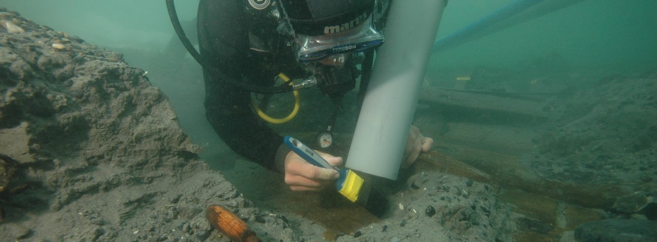
Compared to previous seasons, this year’s excavation has been the equivalent of a microscopic, and therefore highly detailed, study of the submerged and coastal archaeological site. The site was selected to provide an opportunity to gain a detailed understanding of the quotidian nature of this palimpsest of human activity in the area. Led by Professor Jon Adams the team replaced the use of ROVs and SROVs for a downscaled, but fit-to-purpose digital photogrammetric recording method. The team managed to capture more than 65,000 underwater images during the excavation and from this create a daily digital logbook based on more than twenty 3D models representing the full excavation of an area of 100 square metres. This was achieved by using a 3D printed, lightweight camera rig for five GoPro5 Hero Black version which captured one 4K resolution photo per camera each second. Giving the team an unprecedented level of high-resolution underwater recording.

This year underwater visibility in the Bulgarian Black Sea was hindered by an unusual large bloom of coccolithophores, microscopic organisms that thrive in the water column during large seasonal river outflows, which also gathered in astonishing volume – so much so that these blooms can be observed from space (image below). The commitment of the CMA as a world-wide leader in the development and implementation of digital technologies for underwater archaeological recoding was reinforced through this year’s successful excavation and underwater digital recording. This was possible not only by applying novel ways of overcoming challenging underwater conditions, but also by creating a highly detailed daily volume of 3D high-resolution models of the underwater excavation process.

In addition to the focused archaeological excavations at Ropotamo, it was essential to gain an understanding of the palaeogeographical context of the archaeological site, how it relates to the surrounding landscape, and why this particular location was repeatedly visited by multiple generations that lead to the rich stratified archaeological record dating back to the Bronze Age. Prior to the excavations, a detailed geophysical survey of the Ropotamo bay area was conducted by the Black Sea MAP team in order to identify the best location to locate the excavations as well as reconstruct the submerged palaeogeography. An initial geophysical survey, consisting of side scan sonar, multibeam bathymetry and sub-bottom profiling was undertaken in March 2017, but unfortunately the latter failed to gain much penetration of the sandy sediments in the bay in order to understand the underlying topography of the area. As a consequence, the geophysical methodology was adapted to use Vertical Electrical Sounding (VES), which was successful and provided an insight into the distribution and depth of sediments within the Bay, the elevation of the underlying bedrock, as well as the location (and depth) of old river valleys and where to locate the excavation trenches adjacent to these river beds.
VES transects were also taken along the shoreline. Although this survey revealed vital new information about the underlying stratigraphy of the area, it did not have any available stratigraphic information to calibrate the interpretation of the results. Therefore during the Ropotamo excavation a coring programme was undertaken for the purpose of calibrating (ground-truthing) the geophysical model. Using a percussion corer, a series of cores up to 7m deep were taken along the shoreline in order to establish the sedimentary sequence under the beach, including the absolute depths of each sedimentary boundary. The coring was focused across the mouth of a dry river valley that enters Ropotamo Bay east of the excavation site, revealing a sequence of terrestrially-derived fluvially transported clays, up to 5m thick, directly overlying bedrock and beneath the beach sands. Coring was also undertaken within the sea itself using diver-deployed coring apparatus for the same purpose. The coring and geophysical results were found to closely correlate each other, including defining the extent of the buried river channel, validating the geophysical interpretation of the Ropotamo submerged landscape. Sediment samples from the cores were also retained so that they could be further studied in order to learn more about the environment at the time of their deposition.
